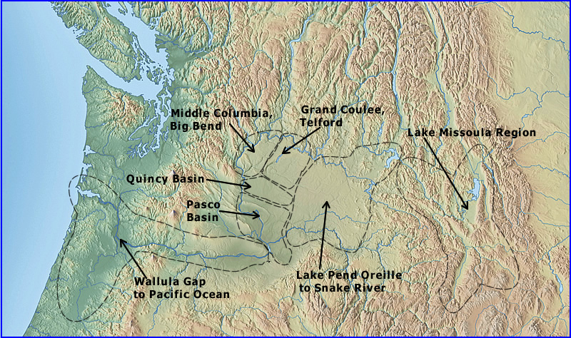
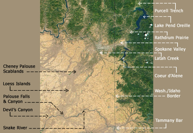
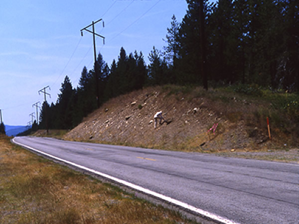
Rocky Mtn. Trench Map
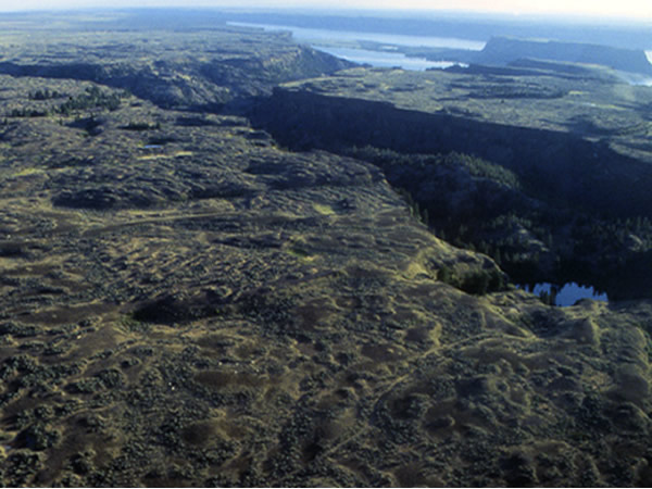
The Rocky Mountain Trench is the long linear, trough-like feature trending northwest to southeast, diagonally across the map. Flathead Lake can be seen at the southern end of the trench. This trench was filled with glacial ice several thousand feet thick during the late Wisconsin Ice Age. All of the water produced by the melting of this substantial volume of ice would have drained south into Flathead Basin. Additionally, montane and piedmont glaciers on adjacent mountain ranges would have flowed into the Rocky Mountain Trench upon melting, and again, would have flowed south into Lake Missoula. Also note all of the other valleys on the southern Canadian Rockies, currently occupied by lakes Okanagan, Upper and Lower Arrow Lakes, Kootenay and others. All of these valleys and adjacent mountain ranges were buried under the Cordilleran Ice Sheet. All of these valleys would have served as conduits for glacial melt water and all of them would have directed the water southward where it would have contributed to the creation of the Channeled Scabland. We would argue, in fact, that this was the primary source of flood water responsible for carving the Telford Scabland tract as well as Grand Coulee and Moses Coulee.
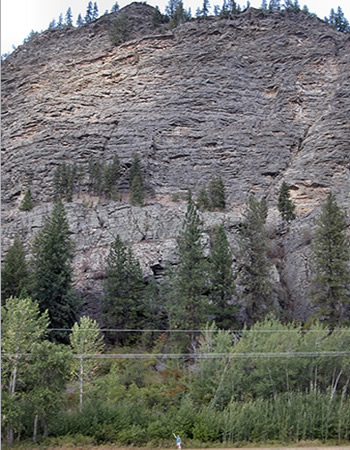
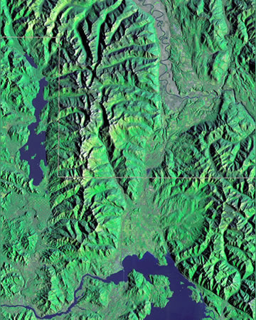
Flathead Lake - Satellite
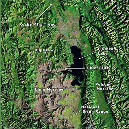
Satellite view of Flathead Lake and surrounding areas. During the Late Wisconsin Ice Age a large glacier called the Flathead Lobe filled the area now occupied by the lake. The glacial snout was just beyond the south end of Flathead Lake, as indicated by the presence there of extensive glacial deposits known as the Polson moraine, named after the town built next to and on top of the moraine. The low-lying area between the mountains is usually called Flathead Basin and served as the northernmost and largest of the basins comprising Lake Missoula. All of the lighter colored areas were underwater, which at its maximum depth at this location was about 1000 feet. The Flathead River can be seen exiting the southwest shore of the lake and winding its way south where it eventually converges with the Clark Fork River.
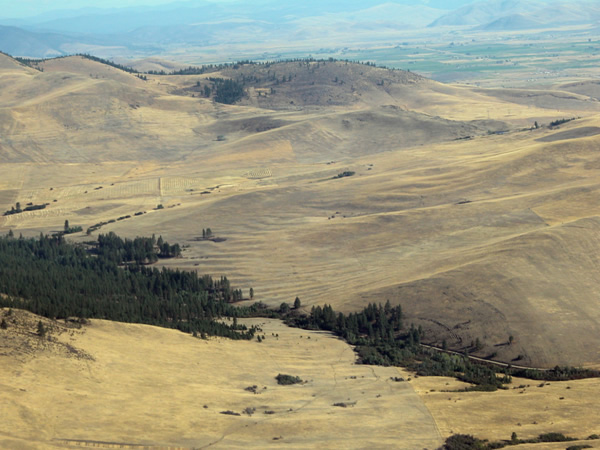
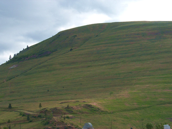
Flathead Lake from Polson
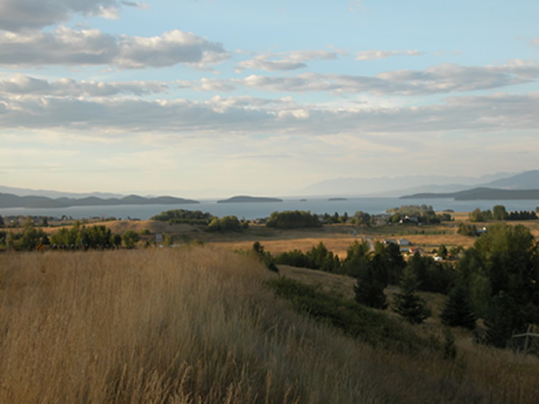
Looking north towards Flathead Lake from atop the Polson Moraine. This moraine marks the southern terminus of the ‘Flathead Lobe’ of the Cordilleran Ice Sheet. During the Late Wisconsin, this lobe filled the entire lake basin visible in this picture. Mission Valley, immediately to the south of the moraine has an elevation of approximately 3,200 feet above sea level at its northern end. Assuming that Lake Missoula existed, the water here would have stood about 1000 feet deep against the ice lobe. From whence came this immense volume of lake water? Is it presumed to be glacial meltwater? Is it presumed to be from rainfall? Or a combination thereof?
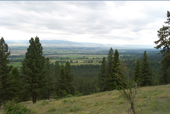
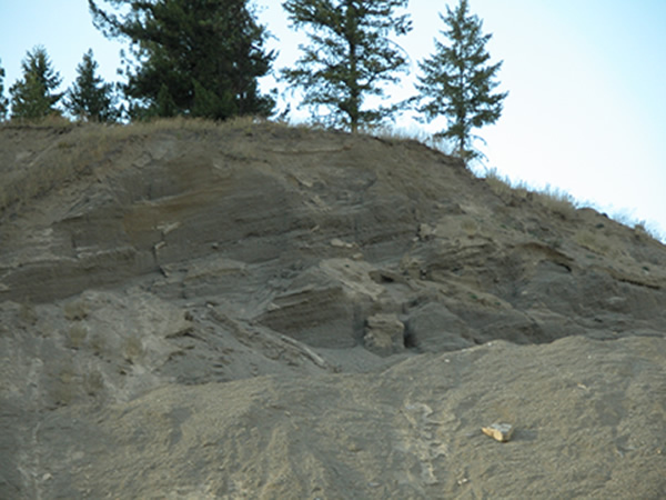
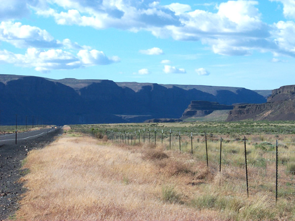
Flathead River
Flathead River exposing lake/flood deposits that accumulated on the bottom of Lake Missoula. Flathead Lake is visible in the distance. Beyond the lake are the Mission Mountains. Looking towards the northeast.
Chief Cliff
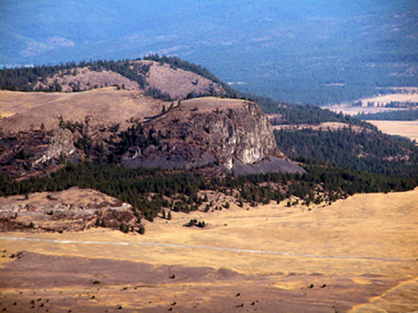
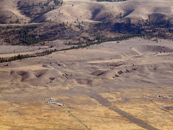
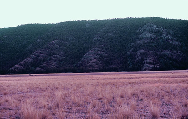
Chief Cliff, a local landmark, is a product of extreme current flows passing between the west margin of the Flathead glacial lobe and the eastern flank of the Salish Mountains, in the process creating what is essentially a truncated spur. Chief Cliff is a significant feature whose presence is not consistent with the prevailing model of a draining glacial lake. The summit of the cliff stands at about 4,150 feet above sea level, or almost exactly the presumed level of Lake Missoula whenever it reached its maximum volume. But at this location the Big Arm sublobe of the Flathead lobe separated the cliff area from the lake by some five miles of glacial ice. In other words the lake did not even reach the area of the cliff. Assuming that Lake Missoula drained out in the region of Lake Pend Orielle, some 180 miles, by water, to the west, there is no reason to assume catastrophic current flows here. Rather it would be a fall in lake level against the southern margin of the Flathead glacier. The erosive flows that created Chief Cliff had to have come from the north, flowing into, rather than out of, the Flathead Basin. This implies that that the ultimate source of the Missoula Flood water was to the north, issuing from melting glacial ice of the Rocky Mountain Trench in British Columbia.
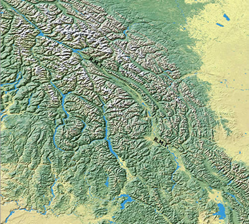
Elmo Moraine Map
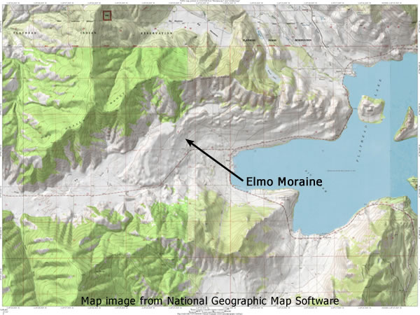
The Elmo Moraine was the product of the Elmo Sublobe of the Flathead Lobe of the Cordilleran Ice Sheet. The moraine can be seen as the hummocky deposit immediately to the west of the Big Arm Bay. State Route 28 passes through a breach in the moraine produced by water from the melting Flathead glacier lobe. Water also drained around the northern edge of the moraine between it and the Hog Heaven Range, creating scabland type erosion. Note the location of Chief Cliff. A large scale flood current flowed west through Big Draw to eventually contribute to the creation of the Camas Prairie giant current ripple field.
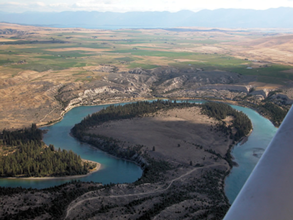
Elmo Moraine from Air
A section of Elmo Moraine from the air. This moraine was first deposited in chaotic piles by the receding glacier and then smoothed into the rounded hummocks by flowing flood water.
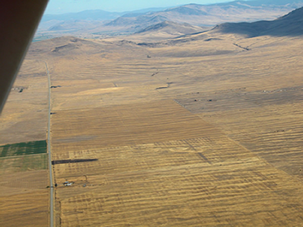
Big Draw 1
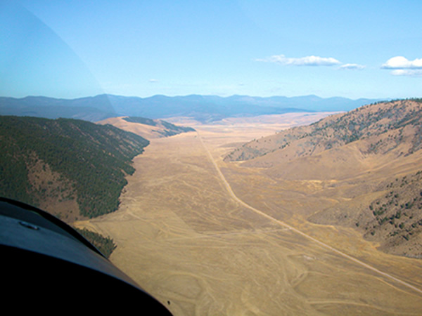
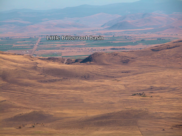
Looking west along Big Draw. Water flow was from behind the viewer towards the west. Flood sediment fills the pre-flood valley trough several hundred feet thick. Note the distinct erosional forms on the south and north sides of the Draw. The south, or left side of the Draw was on the outside of a bend and therefore was subject to higher flow velocities than the north side. At the distal end of the Draw floodwater turned to the south down the Little Bitterroot Valley. Just beyond the hills on the north side of the Draw the valley of the Little Bitterroot River carried additional meltwater emanating from the Salish Mountains to the north.
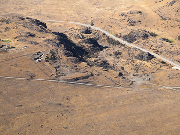
Big Draw 2
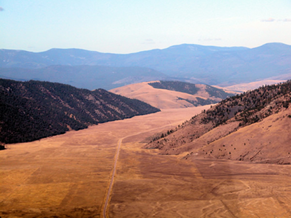
Looking west along Big Draw. This valley was a conduit for the flood waters pouring past Chief Cliff. At the conclusion of the flooding vast amounts of sediment were laid down into the channel trough forming this relatively flat valley floor. Just beyond the hill in the middle ground the flowing water turned south in the direction of Camas Prairie. The highway is State Route 28. The effect of catastrophic flood scouring is prominently displayed on the south side of Big Draw in the contouring of the bedrock hills.
Big Draw Bedrock
Scoured bedrock along the south flank of Big Draw. Catastrophic flood currents flowed across the view from left to right, or from east to west, before diverting south in the direction of Camas Prairie, location of one of Earth’s greatest examples of a giant current ripple field.
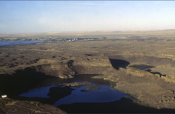
Polson Moraine Map
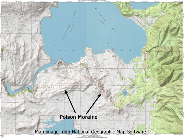
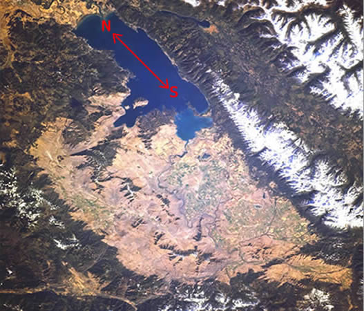
Map of the southern section of Flathead Lake. The irregular hills immediately south of the lake comprise the Polson Moraine, which marks the southern extent of the late Wisconsin Cordilleran Ice in the Rocky Mountain Trench. This southern margin of the glacier would have formed the northern shore of Lake Missoula, against which the water would have stood over 1000 feet deep. We question the veracity of this model of a static body of water restrained only by glacial ice. The question of the source of such a massive volume of water has received far less attention than it deserves. It can only have derived from rain water, glacial melt water, or both. Either scenario is beset with problems. The question must be raised: If the climate is warm enough to support copious rainwater, or melt water, enough to virtually fill the entire catchment basin, how is it possible for that same climate to sustain massive, absolutely stable glacial masses capable of retaining water pressures in excess of 900 psi? We think it is time to go back to the drawing board.
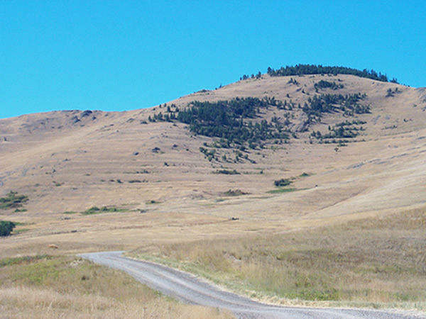
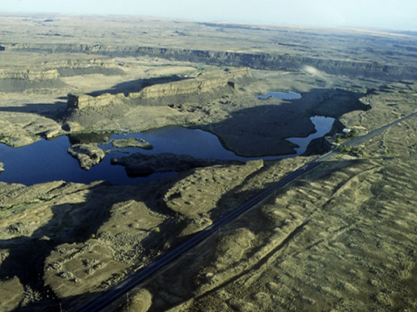
Polson Moraine
The irregular hill in the middle of the photograph is the Polson Moraine. The town in the foreground is Polson, Montana.
Bison Range
The National Bison range is located in the southern section of the Flathead Basin near the confluence of the Jocko and Flathead rivers, just north of the town of Ravali, Montana. The pass through which the modern Flathead River flows served as a southern drainage outlet for Lake Missoula waters emptying from Flathead Basin. The elevation of State Route 212 through the pass is about 2,500 feet asl, which means the water flowing through here that etched the clearly visible strandlines on the hillsides, was, at its maximum, over 1,500 feet deep!
Will’s Creek 1
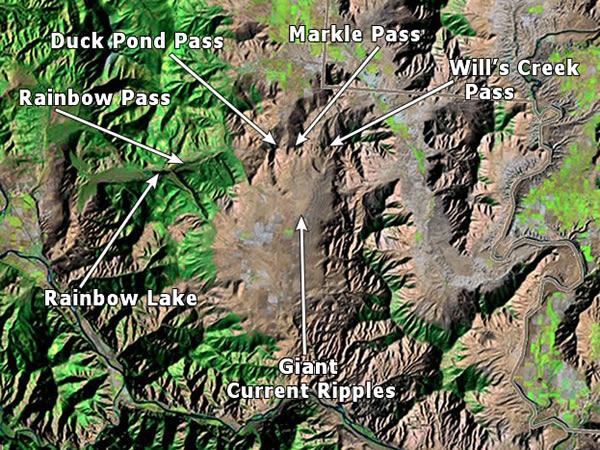
View looking north over the Camas Prairie current ripple field. Will’s Creek Pass is in the middle distance just above the delta bar as seen in Figure 1. Flow direction was toward the viewer. Flood water flowing over Will’s Creek Pass was about 1000 feet deep at its maximum. The ripple field is actually an anomaly as the draining of this basin would have been a slower event for the same reasons as apply to the Bitterroot Valley. The final draining of the basin would have been a rather sluggish affair with no reason to assume stream power adequate to build a ripple field of such extraordinary dimensions. But more importantly the size of the ripples diminishes from north to south.
Will’s Creek 2
Scabland type erosion of bedrock. Also note the large gravel bar just below the pass with giant current ripples on its surface. This is the same gravel bar as seen in preceding Looking south over Will’s Creek Pass. Schmidt Lake occupies a scour trough, Note images. Ripple amplitude and chord length decrease to the south, away from the viewer.
Markle Pass 1
Markle Pass, (pronounced ‘Marko’) view to the north. This was one of three spillways into the north end of Camas Prairie basin. A low range of hills separate the Little Bitterroot basin to the north, from Camas Prairie to the south. The flood water pouring over these hills caused severe erosion as well as slowing of the current. This resulted in the deposition of the massive rippled gravel deposits and delta type formations below the hill complex. The highway going through the pass is State Route 382. Just south of the curve is a pull off zone from which the entire current ripple field is magnificently displayed.
Markle Pass 2
Another view of Markle Pass from above, looking towards the south. The scouring of the bedrock is obvious in this scene. The bend in Highway 382 is about 3,320 feet above sea level, which means the water would have been nearly 900 feet deep as it poured over and through the pass.
Duck Pond Pass
Duck Pond Pass, looking north. This was the westernmost of the three passes through which floodwater flowed from the Little Bitterroot basin into Camas Prairie. The massive scale of the current ripples is evident when compared with the size of the trees. Immediately to the left out of the picture is the eastern entrance into Rainbow Lake Pass.
Giant Current Ripples
Aerial view looking south over the Camas Prairie current ripple field. In this view one can clearly see that the magnitude of the ripples, both amplitude and chord length, diminishes to the south. This is inconsistent with Missoula Flood orthodoxy, which maintains that the water filling the basin drained to the south. A study of the topography in the vicinity of the southern outlet shows that flow should have accelerated, as the flow channel both contracted in width and increased in gradient. From the northern end of the basin, at the head of the current ripple field, to the south in the vicinity of the basins drainage outlet is a distance of about 7 miles. The gradient over this reach is essentially zero, being about 2,850 feet above sea level across the entire basin floor. From the head of the southern outlet of Camas Prairie basin to the present day Flathead River is about 4 miles, over which the elevation drops to about 2,475 feet above sea level. This is a gradient drop of over 90 feet to the mile. So, as the water reached the southern end of the basin it was not only entering a channel with reduced width but steepened gradient as well. With this topographical configuration flow velocity, and hence stream power, would have increased as it approached the outlet, not decreased. However, the current ripple field shown above shows a diminishing stream power. This is only consistent with a current flow entering the basin from the north and declining in power as it passes to the south, in this case the same current which flowed off the flank of the Flathead lobe of the Cordilleran Ice sheet, cutting Chief Cliff as it poured west down Big Draw, then south through the Little Bitteroot Valley, augmented by meltwater flows emanating from Salish Mountain glaciers on the north end of the Little Bitteroot, and over the low range of hills defining the northern rim of Camas Prairie, eroding Duck Pond, Markle and Wills Creek passes in the process. It was these unnamed hills which provided both the velocity retarding obstruction to the current flow and the sediment supply to construct the rippled delta like fans extending off their southern, or downcurrent faces. A silt layer lying on top of the course gravel that forms the bulk mass of the current ripples indicates the actual more prolonged drainage of the basin. Consistent with an decreasing current velocity towards the south is the fact that the silt layer tapers from nothing at the north end of the basin to six feet in thickness towards the southern end.
Giant Current Ripples 2
The extraordinary scale of the Camas Prairie current ripples is evident in this aerial photograph. Note the pick-up truck and trailer and the herd of cattle for scale.
Rainbow Pass
View looking west across the north end of Camas Prairie Basin. We can see several converging ripple fields issuing from Markle and Wills Creek Passes. In the middle distance on the right you can see Rainbow Lake Pass, which served as an overflow spillway out of the basin and into the valley of the Clark Fork River beyond.
Rainbow Pass Map
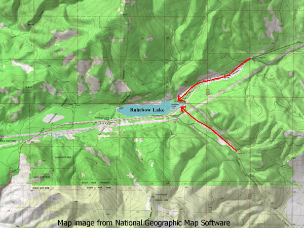
Rainbow Lake Pass and Rainbow Lake. Water entered the pass from the east through the two tributary channels converging at the east end of the Lake. The convergence of the two currents undoubtedly intensified the turbulence at this area and caused the scouring of the trough that is now occupied by the lake.
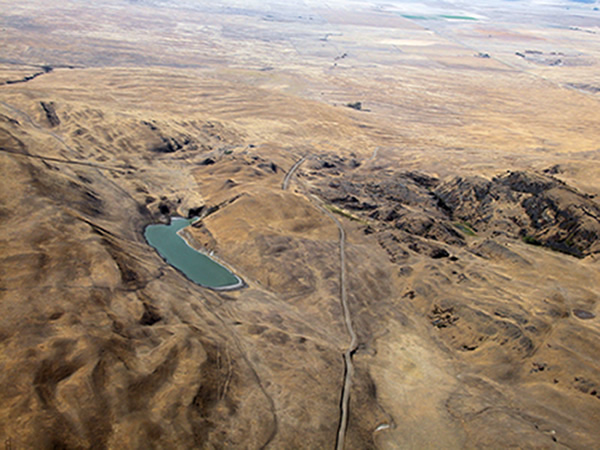
Rainbow Lake
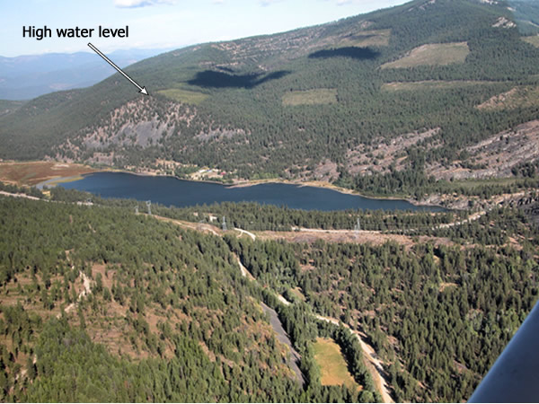
Rainbow Lake Pass from the air, looking north. Floodwater entered the pass from the right. The truncated hill on the northwest end of the lake at its crest has an elevation of just in excess of 4,200 feet above sea level, in other words, the top of the exposed gravel on the truncated surface corresponds with the high flood stage through the pass. Locally Rainbow Lake, as it is identified on most maps, is called ‘Dog’ Lake.
Rainbow Lake 2
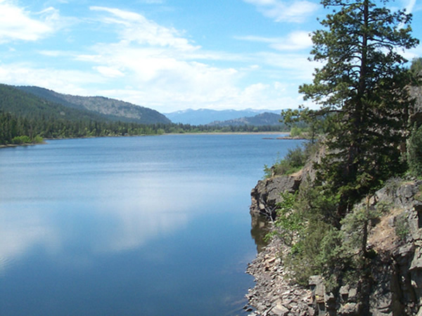
Rainbow Lake – looking west. Massive currents emanating from Camas Prairie Basin poured through this pass from the east. Based upon the elevation of scoured rock surfaces one can estimate that the water flowing through the pass was somewhere around 500 feet deep. The elevation of the pass near the lake is about 3,600 feet above sea level. The maximum elevation of Lake Missoula was about 4,200 feet above sea level, which is consistent with the level of rock erosion on the hillsides.
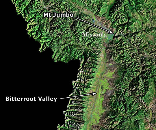
Mount Jumbo
Mt. Jumbo, as seen from eastern Missoula, near the University of Montana campus. The sides of Mt. Jumbo clearly preserve evidence for the former existence of a massive volume of water in the Missoula Basin. We would argue that the strandlines visible on the hillside are the result of the final draining of the basin and are not evidence for separate Missoula Lakes, that they represent the conclusion of the sequence of events known as the Missoula Flood. This does not rule out the possibility of earlier floods which could have filled the basin, only that what we see etched on the hillsides here was the last filling and draining event. Each successive descending strandline represents the lowering of the floodwater as it drained west through the Clark Fork Valley.
Bitterroot Valley
Looking southeast into the Bitterroot Valley. This valley held the southernmost arm of Lake Missoula. In this area of the valley near Lolo, Montana the waters reached a depth of approximately 1000 feet. Lake bottom deposits should consist primarily of varved silts, however, coarse gravel deposits over the floor of the valley indicate the action of flowing water. The first assumption might be that the draining of the lake satisfies this. But whence the source of the gravel? Did the melting glaciers in the Bitterroot Mountains supply it, or was it the result of a torrent filling the valley from the north? Only a detailed study of the provenance of the gravels will answer that question. Valley bottom deposits are shown in the next several images.
Bitterroot Gravels
Rounded gravels and cobbles comprising the floor of the Bitterroot Valley south of Hamilton, Montana. The Bitterroot Valley was the southernmost arm of Lake Missoula and contained water which drained through the outlet at the mouth of the Clark Fork by over 200 miles of twisting, winding valley containing numerous flow constrictions. In the prevailing model of ice dam failure and subsequent lake drainage this distal basin would have undergone a protracted drawdown with relatively sluggish northward flows. Assuming the model of a preflood lake, fed by rainfall and seasonal glacial melting, one would expect to find varved sediments not dissimilar to those found at the Nine Mile Creek locality. Yet, what one finds is consistent with deposition from a turbulent flow. Two likely sources could provide these current flows – rapidly melting montane glaciers in the Bitterroot Mountains and/or flows entering the northern end of the valley from the Missoula Basin.
Bitterroot Gravels 2

Gravel deposits composing the floor of the Bitterroot Valley, exposed in a pit near Hamilton, Montana. In this image the viewer is facing west. One can clearly discern the southward dip of the gravel. This, and the chaotic nature of the deposits are consistent with deposition from a turbulent, south flowing, sediment laden current.
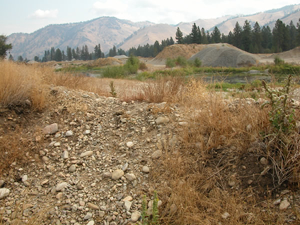
Nine Mile Creek Sediments
Lake bottom sediments exposed in a road cut along Interstate 90 near the mouth of Nine Mile Creek about 18 miles west of Missoula, Montana. These rhythmical sediments most likely represent the final stages of the draining of the Clark Fork Valley since any catastrophic, high-energy currents would have flushed them out during the early stages of the flood. This implies an obstruction to the westward flow out of the valley, most likely the result of a combination of stagnant glacier ice and hydraulic damming. That this is so seems unavoidable given that the floor of the Clark Fork Valley is here approximately 900 feet above the elevation of the valley floor at the presumed flood outlet in the vicinity of Lake Pend Orielle. Without an impediment to drainage out of the valley to the west of this location there would be no reason for the water to be ponded to this level after the lake had emptied. In other words unless the water in the region of the presumed ice dam was in excess of 900 feet there would be no rhythmite deposition here.
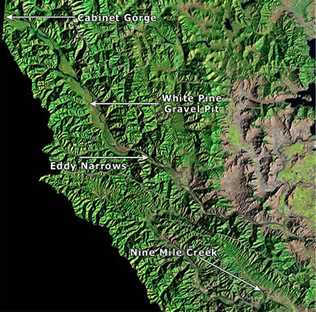
Eddy Narrows
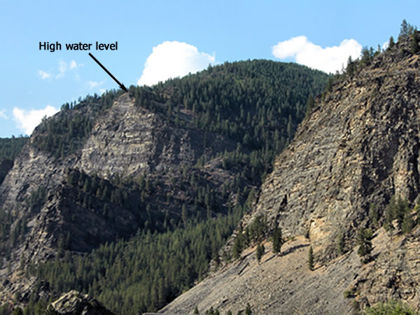
Eroded cliff face near Eddy Narrows in the Clark Fork Valley. The top of the sheared cliff face represents the high water level. Studying evidence such as this J. T. Pardee concluded that the elevation of the floodwater throughout the Clark Fork Valley and presumably of Lake Missoula itself, was about 4,200 feet above sea level.
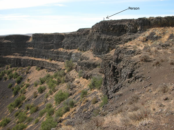
Thompson Falls Scour
Deeply scoured cliff face on a bedrock knob near Thompson Falls, Montana, in the Clark Fork Valley. Current flow was from right to left or towards the northwest. At this point the water was about 1600+ feet in depth, which would have completely submerged the knob. Note the human figure for scale. Current flow velocity through this flood reach probably exceeded 50 mph.
White Pine Gravel Pit
White Pine Gravel Pit, along the south side of the Clark Fork Valley about 12 miles northwest of Thompson Falls, Montana. These gravel layers were produced by current flows moving from the northwest to the southeast, as can be ascertained by studying the dip, or tilt, of the foreset bedding preserved in the gravel layers. In this photograph the flow would have been from the right. The next photograph shows a close up of the upper layers near the top of the exposure, in which the southeast dip is clearly visible.
White Pine 2
Tilted foreset bedding in gravels exposed at White Pine Gravel pit, showing current flow from the northwest. See the discussion of the significance of this in the photograph of Dry Creek Gravel pit further down in this section.
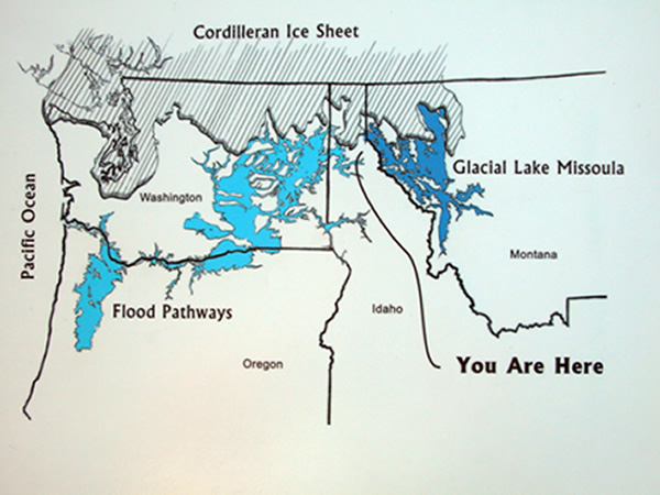
Cabinet Gorge Dam
This is a graphic that is displayed at the Cabinet Dam and Gorge overlook depicting the prevailing view of Lake Missoula, the Missoula Flood and the region of the Channeled Scabland. This shows the hypothetical ice dam occupying the Purcell Trench, the region now occupied by Lake Pend O’reille. Of course, the condition depicted here would not have actually occurred because when the flood routes throughout the Channeled Scabland, along the Columbia Gorge and in the Willamette Valley were filled with water as shown here, the ice dam would necessarily have already failed and the basin of Lake Missoula would have been emptied of water. If, on the other hand, the flood was the result of a catastrophically accelerated melting of the Cordilleran Ice Sheet, then the situation depicted here may not be that far off the mark. A major difference between this scenario and the orthodox model is that the current flows causing the erosion of the scabland occurred simultaneously with glacial meltwater flows filling the reservoir of Lake Missoula.
Cabinet Gorge Graphic
This is a graphic that is displayed at the Cabinet Dam and Gorge overlook depicting the prevailing view of Lake Missoula, the Missoula Flood and the region of the Channeled Scabland. This shows the hypothetical ice dam occupying the Purcell Trench, the region now occupied by Lake Pend O’reille. Of course, the condition depicted here would not have actually occurred because when the flood routes throughout the Channeled Scabland, along the Columbia Gorge and in the Willamette Valley were filled with water as shown here, the ice dam would necessarily have already failed and the basin of Lake Missoula would have been emptied of water. If, on the other hand, the flood was the result of a catastrophically accelerated melting of the Cordilleran Ice Sheet, then the situation depicted here may not be that far off the mark. A major difference between this scenario and the orthodox model is that the current flows causing the erosion of the scabland occurred simultaneously with glacial meltwater flows filling the reservoir of Lake Missoula.
Dry Creek Gravel Pit
Gravel pit near the mouth of Dry Creek, a tributary to the lower Clark Fork River. These deposits clearly display the effects of current deposition, note the foreset bedding dipping (tilting) to the left in the picture, indicating a current flow in that direction. In this photograph the viewer faces south. Note that the current flow was from right to left across the picture, which, in the field, was toward the southeast. However, current flows from the draining of Lake Missoula would have been in the same direction as the modern flow of the Clark Fork, which is towards the northwest, or directly opposite the palaeocurrent direction indicated here. Other gravel outcrops along the southside of the Clark Fork valley display the same orientation, showing current flowing into the Clark Fork from the northwest. This inconsistency has not been adequately addressed by current theory, but again, is consistent with huge water flows originating from the north, from melting ice of the Purcell Trench.
Purcell Trench
Purcell Trench in northern Idaho and southern British Columbia. This great north-south trending valley seen along the center of this digital map plays a central role in developing a detailed model of the Missoula Floods. Evidence supports the conclusion that the Purcell Trench was filled with a glacial lobe of the Cordilleran Ice Sheet. The ice extended into the basin now occupied by Lake Pend Orielle, seen at the bottom center of the image, and apparently pushed on about another 20 or so miles beyond the southern edge of that lake. It is this lobe which is presumed by the prevailing flood origin theories to have formed the obstruction to the westward flow of the Clark Fork River, thereby damming the river and forming Lake Missoula as a consequence. We believe that the field evidence supports the conclusion that this north-south trending valley carried enormous amounts of meltwater that discharged south through the Spokane Valley below Lake Pend Orielle and contributed as much to the formation of the Channeled Scabland as water issuing from the valley of the Clark Fork. The north flowing Kootenay River can be seen meandering across the floor of the trench in the upper part of the picture.
Pend Orielle Map
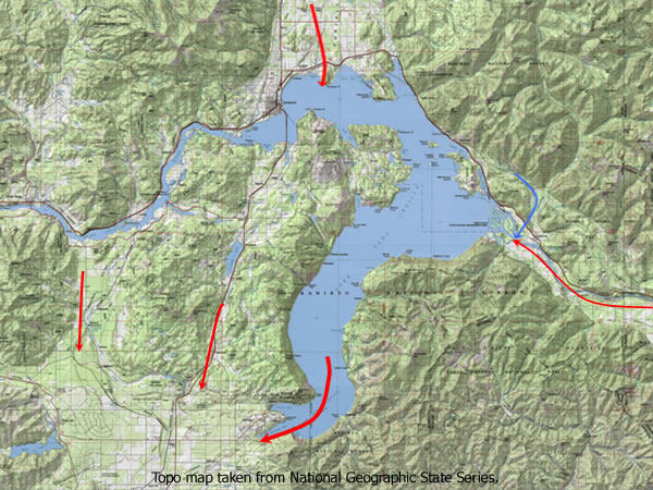
Lake Pend Orielle (pronounced pondaray), the presumed site of the ice dam. While there is no doubt that the basin of this lake held a large lobe of glacial ice, usually called the Purcell Trench lobe after the wide valley into which the north end of the lake opens, we question whether this ice ever actually served to retain the water of Lake Missoula for any extended period of time. The position of the glacier/lake interface is usually assumed to be in the region of the Cabinet Gorge dam, almost on the Idaho/Montana state line, which defines the eastern edge of this map. The lower and largest arrow shows the main discharge point of floodwaters exiting the basin. The other two arrows indicate additional discharge paths, all converging into the Spokane Valley. The arrow at the north end of the lake indicates both the glacier flow direction into the basin of Lake Pend Orielle and what we surmise to be a flow path for glacial meltwater emanating from the Purcell Trench in British Columbia. The right hand arrow indicates the flow direction for floodwater emanating from Clark Fork River Valley after the presumed rupture of the ice dam. But here refer to the discussion regarding flow direction evidence at White Pine and Dry Creek gravel pits. The blue arrow points to the position of Dry Creek gravel pit, which you can see is very close to the discharge point for currents presumably coming from the southeast.
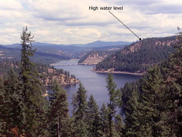
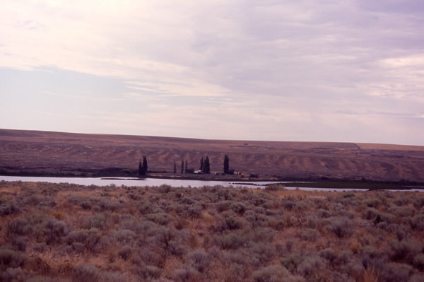
Pend Orielle from Roundtop
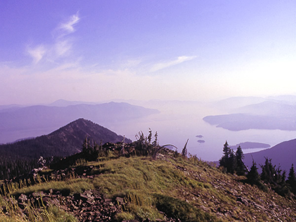
Looking southwest across Lake Pend Oreille, this photograph was taken from Roundtop Mountain. Smoke from a nearby forest fire has settled over the lake.
Rathdrum Current Ripples
Giant current ripples exposed in a roadcut along State Route 54, west of Athol in the Idaho panhandle. This would have been very close to the presumed point of Lake Missoula outflow immediately below, or south of, the glacial lobe occupying the Purcell Trench. A second ripple can be seen in the middle distance, also truncated by the highway. Every day thousands of travelers pass these immense current formed ripples and never suspect, or even give the slightest thought to the meaning of these crude gravel banks and the events of which they are the aftermath. How many of them, as they drive past several dozen of these low hills in succession understand, contemplate or consider in the slightest, that they testify to the passage over this landscape of a an ancient temporary river some 400 to 500 feet deep and ten miles wide.
Couer d’Alene
A view to the north, overlooking Beauty Bay on Lake Couer d’Alene. The bridge in the distance carries I-90 across the northern end of the lake. The normal lake surface elevation of Coeur d’Alene is 2,125 feet above sea level. This photograph was taken from an overlook with an elevation of about 2,600 ft asl. During the Missoula Floods lake Couer d’Alene received spillover from the main current flow through the Spokane Valley to the northwest. The entire basin of the lake formed a temporary back-flood reservoir, which at its greatest depth reached very close to the position from which this photograph was taken, or about 400 feet above the present lake level. The arrow shows roughly the position the water reached on the side of Mineral Ridge during peak floods. The truncated hill just beyond I-90, with an elevation of about 2,430 ft. asl, would have been completely submerged during peak floods, the truncation itself being a product of the erosive power of the currents.
Spokane Valley / Rathdrum Prairie Topo
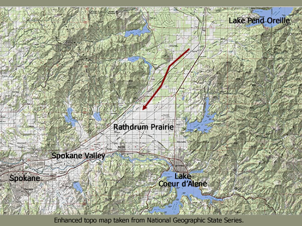
This map shows the south end of Lake Pend Orielle in Idaho (in the upper right hand corner) Rathdrum Prairie, the Spokane Valley and the north end of Lake Coeur d’Alene in the lower center. This trough, which is actually the lower end of the Purcell Trench of southern British Columbia, was occupied by glacial ice during the Late Wisconsin. It was this ice that presumably served as the dam retaining the waters of Lake Missoula. Much more work remains to be done in order to decipher the exact relations between glacial terminus, glacial thickness, position of glacier/lake interface, mode of dam failure, mode of glacial readvance (assuming multiple ice dams). For example, where was the glacial terminus at the commencement of the first flood? How far did the ice advance before it could effectively form a seal of sufficient stability to cause another filling of Lake Missoula? Given the pressure at the base of a water column many hundreds of feet deep, how could any glacier resist all seepage until the water stood over 2000 feet against the dam?! The unresolved paradox of the prevailing flood model is simply that a temperate glacier would never form a 100% impermeable seal, and a cold based polar glacier that would have any possibility of forming such a seal is incompatible with a climate that allows the accumulation of over 500 miles of water, whether rainfall or glacial meltwater. The Spokane River can be seen exiting the north end of Lake Coeur D’Alene, then flowing to the west through the city of Spokane, Washington. The arrow shows the direction of the current flow.
Spokane Topo
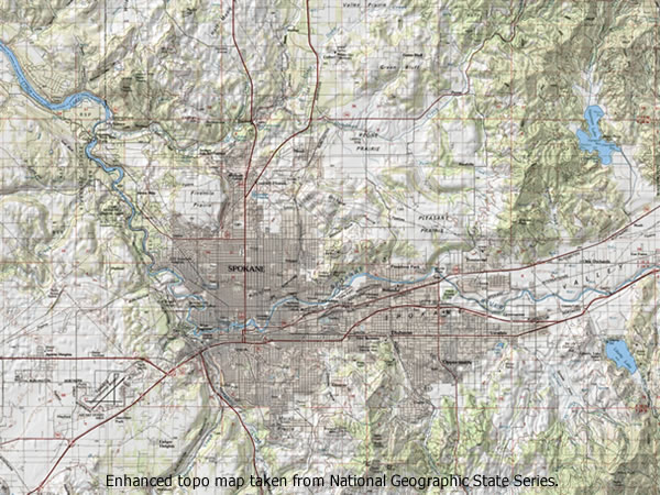
Spokane, Washington and surrounding area. After the Spokane River flows west through the city of the same name it turns to the northwest, as can be seen on the map. Tremendous flood flows were diverted from the main flood route through the Spokane Valley to follow this route. Evidence of the passage of catastrophic currents is evident along the reach of the river once it passes out of the city. The majority of the flood water, having passed over the area now occupied by Spokane would have discharged south to form the Cheney Palouse scabland tract.
Spokane River Boulders
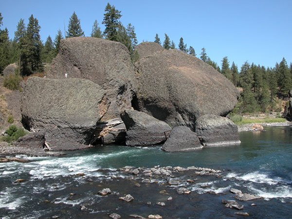
Gigantic incompletely quarried basalt blocks along the Spokane River northwest of Spokane in Riverside Park. This reach of the river served as a conduit for a secondary flow diverted off the principle flood route. The Spokane is a tributary to the Columbia River and joins it about 40 miles west of here, in the area of Fort Spokane. These eroded formations provide important evidence as to the process by which the giant basalt erratics found throughout the flood region of Washington, would have been created. Note the person in white standing on the left boulder.
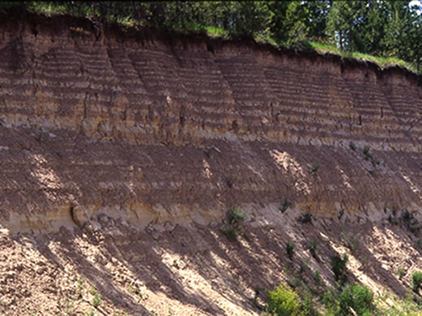
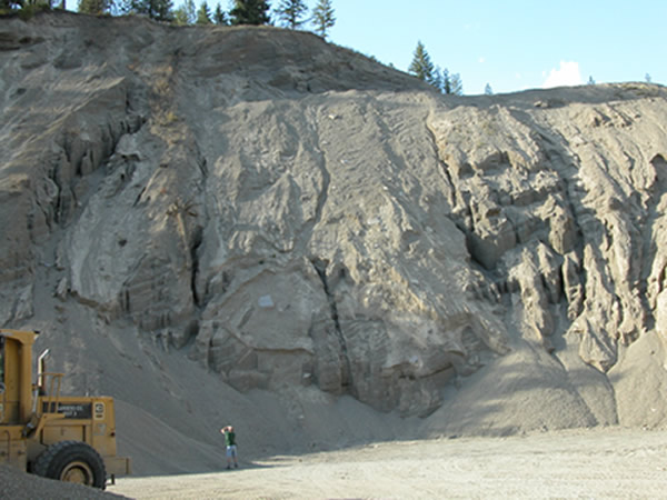
Latah Creek Gravel Deposits
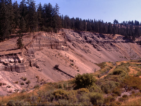
Gravel deposits along Latah Creek, also called Hangman’s Creek, about 3 miles south of Spokane, visible just off of U.S. Route 195. The hills in the background are remnant basalt called Moran Prairie with an elevation of about 2,300 (700 m) feet above sea level. The upper surface of the terrace in which the gravels are exposed is about 1,960 feet (597 m) above sea level. The character of the sediment displays both sublacustrine and subaerial deposits. Foreset bedding and ripple laminations are consistent with two sources of water flow, one from the upland area of Moran Prairie and the other originating in the Spokane Valley and flowing up the Latah Creek valley. Controversy exists here, as elsewhere, concerning the number of flood events responsible. Most researchers have concluded that multiple floods are represented here, with each flood event separated from the one preceding and the one following by silt and clay couplets, up to a maximum of 125 units, that are interpreted to be varves. If they are, in fact, annual varves, then their presence is an indication of the number of years elapsed between deposition of successive layers of flood sand and gravel. Up to 15 layers of the flood sand and gravel have been identified in the exposure, which, at its greatest extent is about 150 feet high.
Scabland
This aerial photograph taken from about 1,200 foot altitude over the Cheney-Palouse area clearly shows the appropriateness of the term scabland to describe the extreme erosion and scouring of the Columbia basalt plateau. Note highway in upper right for scale.
The Cheney Palouse Scabland is the easternmost tract of scabland. It takes its name from the town of Cheney, Washington, which is located near the drainage divide that marks the head of the tract, and from the rolling Palouse loess landscape across which it passes, which in turn takes its’ name from the Palouse River. The Cheney-Palouse scabland tract is the greatest feature of its kind on earth. It is the type specimen for the definition of Channeled Scabland. From east to west the tract is some 20 miles wide and from its beginning at the latitude of Cheney to its terminus at the confluence with the Snake River to the south is about 75 miles. Within the Scabland area are islands of loessial soil that escaped being entirely washed away by the raging currents. The entire complex occupies an area of approximately 1,500 square miles. Once the waters reached the Snake River they flowed up the valley as well as down. The waters that flowed down the Snake to the west discharged from the mouth of the Snake adding to the inflow into Pasco Basin and contributing to the formation of Lake Lewis. The waters that flowed up the Snake created a huge silt laden backwash that reached all the way beyond Lewiston, Idaho, building sedimentary beds almost to the mouth of Hell’s Canyon. At the most distal point of flow the waters reversed direction and flowed back down the Snake to rejoin the rest of the floodwater accumulating in Pasco Basin. As the water rose to nearly a thousand feet behind Wallula Gap on Pasco Basins’ southwestern rim, it backflooded into all the tributary valleys such as the Walla Walla valley and the Yakima valley that adjoined it. These back floods that deposited the layered rhythmites seen at exposures in Burlingame Canyon, Zillah, Touchet, Mabton and numerous other locations.
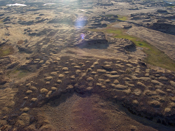
Islands of Loess
Islands of loess adjacent to a scabland tract in the Cheney-Palouse scabland area. It was the juxtaposition of features such as this that Bretz realized could only be explained by invoking gigantic floods.
Loess Island
Loess island. This is a typical example of the many hydrodynamically shaped loess islands found throughout the Cheney-Palouse Scabland area. The top surface of the island corresponds to the preflood landscape surface, all material surrounding the island was swept away by the powerful currents. The surface of the island stands about 200 feet above the surrounding plain.
Rolling Palouse
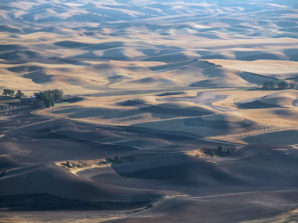
The Rolling Palouse: hills of fertile, wind-blown silty material called loess, probably accumulated over several ice ages. Thickness of the deposits ranges up to 250 feet. Large volumes of the Palouse loess were swept away during the course of the Missoula Floods, most especially in the area of the Cheney-Palouse scabland. It is this material that forms the teardrop shaped islands against the background of dark exposed basalt, seen so readily in the aerial and satellite photos of eastern Washington. The “stormy sea” topography, as it has been so called, probably results from its temporary immersion in sluggish floodwaters during the greatest of the Missoula floods, possibly due to excessive rainfall associated with the flooding.
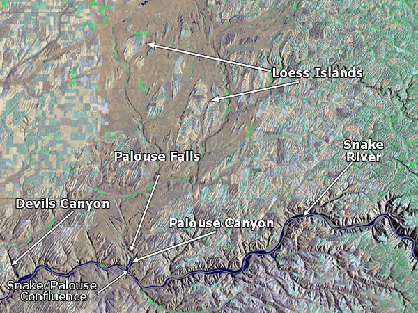
Snake River & Canyons Topo
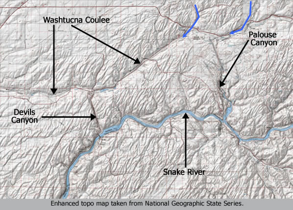
Towards the southern section of the Cheney-Palouse Scabland tract the gradient became steeper. This caused an increase in erosive potential of the flood waters that increased the depth of scouring. The Palouse Canyon was the major byproduct of the intensified erosion. The underfit condition of Palouse Falls cataract is a clear indication of the power of the flood flow. One consequence of the flood was that the channel of the pre-flood Palouse River was completely diverted from its former route, which passed down the area now occupied by Washtucna Coulee. The diversion took place very near where the town of Washtucna now stands. Prior to the Missoula flood the reach now occupied by Palouse Canyon was the divide between the pre-flood Snake and Palouse Rivers. In other words, the floodwaters so completely overwhelmed the pre-flood Palouse River channel and valley that the waters spilled over the divide to the south cutting a new channel completely across it. It is this superimposed incision that the modern Palouse occupies, from the diversion point at Little Palouse Falls to its confluence with the Snake about 9 miles to the south. Another spillover canyon further downstream is Devil’s Canyon. Blue arrows show the direction of flow of water issuing from the Cheney-Palouse vicinity.
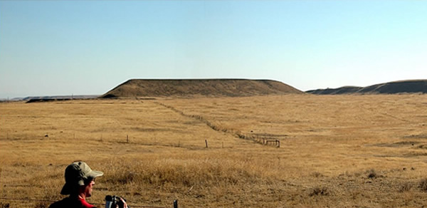
Palouse Falls
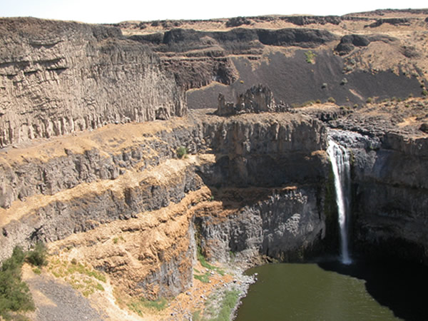
The present day Palouse Falls is a diminutive remnant of the waterfall that gouged out this cataract and scoured the surrounding bedrock. During the peak of the floods this entire scene was overwhelmed with raging currents pouring off of the Cheney-Palouse scabland tract.
Palouse Canyon
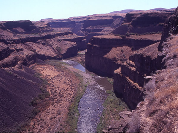
Looking south into Palouse Canyon just below Palouse Falls. The canyon at this location is about 400 feet deep. The scouring on the bedrock adjacent to the canyon implies that the canyon flowed at least brimful. The most likely scenario is that there existed a pre-flood zone of weakness, perhaps a fault line, along which the floodwaters concentrated to erode the canyon. Only some of the water passing over the Cheney-Palouse region contributed to the formation of this canyon, the remainder passed southeast along a route corresponding to Washtucna Coulee, which was actually the channel of the pre-flood Palouse River.
Snake / Palouse Topo
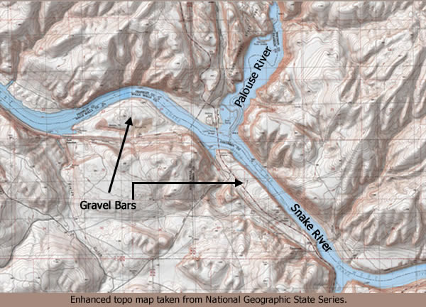
Once the flood reached the southern limit of the Cheney-Palouse area it encountered the Snake River. The modern Palouse River now flows through Palouse Canyon, a great erosional gash that resulted from the water overwhelming the preflood divide near the head of Washtucna Coulee. Water discharging from the mouth of Palouse canyon diverged up the valley of the Snake as well as down. Two massive gravel bars corresponding to this flow divergence project from the mouth of the Palouse, one of them trends upriver towards the southeast and the other downriver, towards the west. The relationship will become clear by reference to the map. This is outwash from the erosion of Palouse Canyon. The gravel bars display giant ripple trains on their surfaces. The waters that flowed downriver to the west discharged from the mouth of the Snake adding to the Pasco Basin inflow and contributing to the formation of Lake Lewis. The waters that flowed up the Snake created a huge silt laden backwash that reached all the way beyond Lewiston, Idaho, building sedimentary beds almost to the mouth of Hell’s Canyon. At the most distal point of flow the waters reversed direction and flowed back down the Snake to rejoin the rest of the floodwater accumulating in Pasco Basin from other sources. As the water rose to nearly a thousand feet behind Wallula Gap on the Basins’ southwestern rim, it backflooded into all the tributary valleys that adjoined it such as the Walla Walla and the Yakima. These back floods deposited the layered rhythmites seen at exposures in Burlingame Canyon, Zillah, Touchet, Mabton and numerous other locations.
Massive Gravel Bars
One of the two massive gravel bars formed by outwash from the cutting of Palouse Canyon. This one is to the southeast of the mouth of the Palouse River, deposited by the great backwash up the Snake River. For clarification see that map. Note the eroded bedrock on the hills above the gravel bar, indicating the extraordinary depth of the floods at their peak. The elevation of the surface of the bar varies from about 690 to 700 feet above sea level, making it about 150 above the present day level of the Snake River.
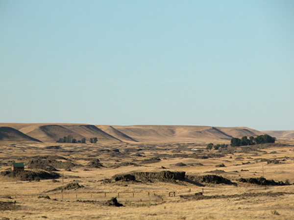
Devils Canyon
Looking north into the mouth of Devil’s Canyon. Like Palouse Canyon, Devil’s Canyon formed as the result of the incapacity of the pre-flood Palouse River to convey the incredible volume of floodwater, forcing the water to spill over the existing divide separating the Palouse from the Snake Rivers. Unlike Palouse Canyon, Devil’s Canyon is not presently occupied by a stream or river.
Tammany Bar
Tammany Bar gravel and silt deposits. This is a truly remarkable deposit, found along the East bank of the Snake River at its junction with Tammany Creek, just south of Lewiston, Idaho. What makes this exposure so valuable is that it displays deposits from the two most powerful floods known in North America in one outcrop. Clearly visible are the two distinct sedimentary provenances, gray colored coarse gravel deposits overlain by a finer grained, buff colored silt. The coarse gravels forming the lower layer are deposits of the great Bonneville flood, originating from the overflow of Lake Bonneville, over 400 miles to the southeast in Utah, and the juxtaposed silts were deposited by Missoula backfloods originating, presumably, from the overflow of Lake Missoula in the region of Lake Pend Orielle, Idaho, some 120 miles north of this site. The current that deposited the Bonneville gravels was moving across the picture from right to left. The current that deposited the Missoula silts first moved from left to right, and then from right to left. Note the layer of loess capping the silt. The significance of this site is such that it will be addressed further in the section covering southern Idaho and northern Utah, in which we shall explore the extraordinary Bonneville Flood. Note person near middle of picture for scale.
Telford Tract Satellite
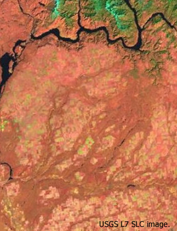
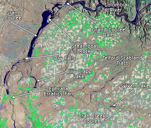
Telford Scabland Tract is the westernmost of the two great tracts of Channeled Scabland that show up so prominently on satellite photographs of eastern Washington. Not quite as extensive as Cheney-Palouse, it is nonetheless an impressive piece of erosion. Like Cheney-Palouse the head of the tract lies about 2400 ft. above sea level. U.S. Route 2 skirts very close to this elevation between Wilbur and Davenport and closely defines the northern boundary of the tract. The head of the main spillway reaches from roughly Creston Butte on the west to the town of Davenport on the east, a distance of about 20 miles. From there the waters flowed south for about 10 miles before splitting into a complex branching system that met and joined flood waters discharging south from Grand Coulee. This merging of flood streams created a vast ponding in Quincy Basin, which in turn found multiple outlets. Goose Creek and Sinking Creek now occupy two major spillways diverging from the main scabland tract near its head. They join southwest of Wilbur to form Wilson Creek, which occupies a major scabland trough and is readily seen as a substantial north-south trending scabland tract lying between the main Telford tract and Grand Coulee to the west. All of the branching channels of the Telford Tract discharge into Crab Creek Coulee, which is a major east-west trending scabland spillway that carried overflow from Cheney-Palouse. Many scenic lakes now occupy the deepened scour troughs throughout the Telford tract, especially in the aptly named Lake Creek reach, which is the major intermediate tract after the initial dividing of the waters. In Fig.1 it can be seen as the prominent NE – SW trending string of lakes in the center of the picture.
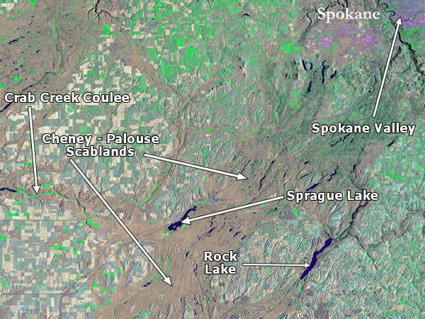
Crab Creek Satellite
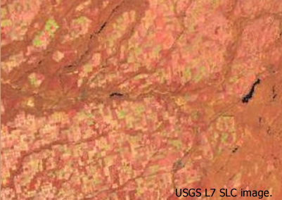
Crab Creek Coulee is the east-west trending spillway that carried overflow from the main flood reach responsible for carving out Cheney-Palouse scabland. It is a stark indication of the prodigious volume of floodwater pouring south over the rolling Palouse, water which completely overwhelmed the pre-flood stream divides. Crab Creek Coulee is the largest of some five major east-west spillways flowing westward out of and away from the main flows that created Cheney Palouse scabland. It shows up in satellite photographs quite prominently, being the large horizontal dark band that intersects the southern reaches of the Telford scabland. In reconstructing the flood chronology it would appear that at the southern end of Billy Clapp Lake floodwaters emanating from Grand Coulee, Telford Scabland and Cheney-Palouse all merged to flow together into Quincy Basin.
Sylvan Lake
Sylvan Lake occupies a scour trough along Crab Creek Coulee. This coulee carried waters discharging west from the main channels of the Cheney Palouse flows. While the main flood currents from Cheney Palouse were carried south to the Snake River, so great was the discharge that there were numerous divide overflows to west. These flows, along with Crab Creek flow joined the floodwaters passing through the Telford channels and Grand Coulee, from whence they were conveyed to the Columbia River at various points. The unambiguous evidence of massive current flows are the giant ripple fields found along the coulee floor.
Pacific Lake Basalt
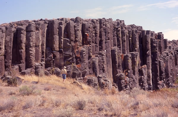
Flood exposed columnar basalt near Pacific Lake in the southern end of the Lake Creek channel of the Telford Scabland Tract.
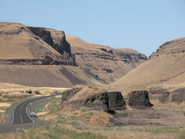
Grand Coulee
Grand Coulee could very well be the most magnificent example of a receded cataract gorge on the planet. The coulee in its entirety is actually two canyons whose total length is nearly 50 miles from north to south. Upper Grand Coulee is approximately 25 miles in length and is separated from the lower coulee by an unexcavated section roughly mid-length of the whole feature. The width of the coulee varies from about one mile to about five miles in width at its’ widest section, with an overall depth of about 800 to 900 feet. Upper Grand Coulee heads at the Columbia River valley at the site of the modern Grand Coulee Dam. The coulee head forms a notch on the south wall of the Columbia Valley, and with an elevation of some 1550 feet, lies about 300 feet above the elevation of the present day Columbia River.
One remarkable property of both Upper and Lower coulees is the fact that their floors have essentially no gradient. In some places there is actually a reverse gradient. This, of course, is totally uncharacteristic of any canyon or valley associated with normal stream erosion.
The entire length of the coulee relates to the presence of a structural feature of the basalt bedrock called a monocline, in this case the ‘Coulee Monocline.’ Upper Coulee converges upon the monocline from the northwest while Lower Coulee follows the axis, or limb, of the monocline. These relations are readily seen on the map of Grand Coulee. The Coulee Monocline long predated the flood that created Grand Coulee. Undoubtedly, the upwarping, which produced the monocline, fractured the bedrock along its axis. This zone of weakened rock was exploited by the floodwaters as they spilled across the divide that formed the southern rim of the Columbia Valley.
Upper Grand Coulee now serves as a reservoir for the storage of water drawn from the Columbia River at the Grand Coulee dam site. Another dam built at the southern end of Upper Grand Coulee, about 1¾ mile above Dry Falls Cataract, retains this body of stored water which now goes by the name of Banks Lake.
The creation of Grand Coulee is generally attributed to a diversion of the Missoula Flood waters by the damming of the Columbia River valley west of the area of Grand Coulee dam by the Okanogan Lobe of the Cordilleran Ice Sheet.
The great cataract formation known as Dry Falls marks the north or upper end of Lower Grand Coulee. Had the flooding not ceased when it did this cataract would have continued to recede north and after traversing an additional 5 miles or so would have connected Upper and Lower Coulees into a single continuous canyon.
Grand Coulee Topo
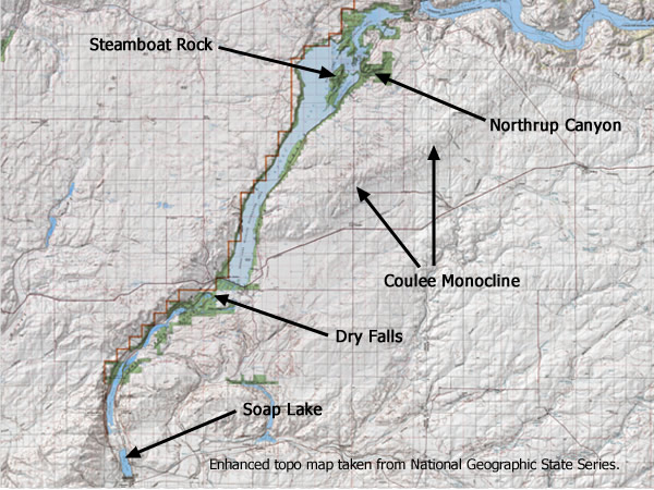
Upper and Lower Grand Coulee. This map shows Grand Coulee in its entirety, from its head at the Columbia River to its outlet into Quincy Basin, marked by Soap Lake. Dry Fall marks the top end of Lower Grand Coulee. Dry Falls dam more or less defines the bottom end of Upper Grand Coulee. The 1.7 miles or so of scoured basalt between these two features is relatively unexcavated.
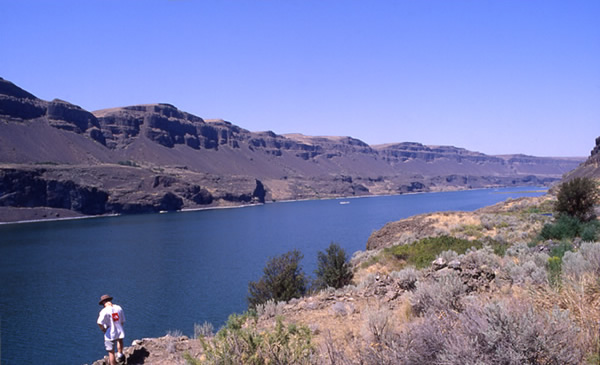
Aerial Head of Grand Coulee
Looking south from the head of upper Grand Coulee. Note Steamboat Rock in the middle distance. Steamboat rock is an erosional remnant of a catastrophic flow between 300 million and ½ billion cubic feet per second. Coulee walls are over 800 feet high and at Steamboat Rock the coulee is over 5 miles wide. This photograph was taken before the utilization of the upper coulee as a water storage reservoir. Photograph from Weis, P. and W. Newman; The Channeled Scablands of Eastern Washington, inside front cover.
Aerial Steamboat Rock
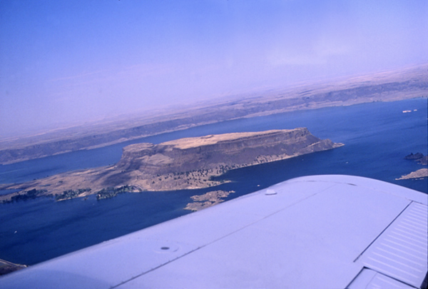
This impressive mesa is over a mile long and 800 feet high. It is a prominent feature of Upper Grand Coulee. Steamboat Rock is a bedrock remnant of the pre-flood basalt which was excavated in the formation of the coulee. A modern analog would be Goat Island which separates American Falls from Horseshoe falls at Niagara. During the latter stages of the floods there would have been receding cataract waterfalls on both sides of Steamboat Rock. They probably joined into a single cataract once they were eroded past the rock which ultimately eroded headward to the top of the coulee, near the site of the modern Grand Coulee Dam.
Northrup Canyon
Northrup Canyon, looking south. Steamboat Rock is visible in the upper right, in front of the canyons mouth. Once it is recognized, the scouring effects of catastrophic water erosion on the Columbia basalts is obvious, as can be seen magnificently displayed here. It is likely that Northrup Canyon formed as a result of the flood waters exploiting a structural weakness in the basalt, even as the formation of Grand Coulee involved the exploitation of a zone of weakness associated with the formation of the Coulee Monocline.
Dry Falls Aerial
Dry Falls cataract from the air, looking northeast. Dry Falls demarcates the transition from upper Grand Coulee to lower Grand Coulee. Dry Falls dam and the southern end of Banks Lake reservoir is visible in the middle left. The town is Coulee City. The white building in the lower left of the photograph is the Dry Falls Visitor Center. The escarpment is nearly 400 feet high. The peak flood at the time it was flowing over this cataract had a depth of around 400 feet also. The cataract would have shown up more as a downward bump in the water surface, rather than an actual waterfall in the sense that we normally think of it. During the waning stages of the flood, the current would have looked more like a traditional waterfall in the sense of Niagara Falls. Also, during the course of the flood the position of the cataract would have continuously migrated upstream, traveling a total distance of 18 miles from what is now the coulee mouth. The current location of the cataract was simply determined by its position at the time the floodwaters ceased to flow. If the up-current migration continued, lower Grand Coulee would have merged with upper Grand Coulee to form a continuous canyon some 50 miles in length. The width of flow in this scene would have extended to the light colored hills visible on the horizon some 10 to 12 miles distant.
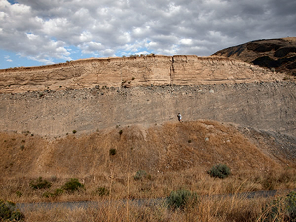
Dry Falls Rim
The rim of Dry Falls cataract. Looking at the scale of this feature, of which we only see a small part here, one can appreciate the utter insignificance of a human being when contrasted with the magnitude of forces capable of creating Dry Falls.
Umatilla Rock
Umatilla Rock from the air, looking southeast. State Route 17 is seen here as it skirts the western edge of Grand Coulee. The white building next to the highway is the Dry Falls Visitor’s Center. The section of cliff projecting into the coulee from the left is a part of the great cataract. The cliff opposite Umatilla Rock is the eastern rim of the coulee. Floodwaters were not confined to the coulee itself as channeled scabland beyond the eastern rim reaches almost to the horizon, a distance of some 10 miles. It is likely that the flood was initially a sheet flow that concentrated along a pre-existing zone of weakness induced by the uplift of the Coulee Monocline. Once the coulee was downcut it probably captured the bulk of the floodwater from then on. But then again, maybe not, it all depends upon the magnitude of subsequent floods.
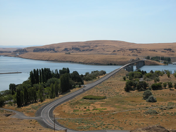
Mouth of Lower Grand Coulee
Mouth of lower Grand Coulee, near Ephrata, Wash., looking north into the Coulee mouth.